The Fernhurst Society
Fernhurst in Living Memory, part 1
Highways Old and New, or a Trip Down Memory Highway
by Brenda Newman, 2004.
Click on any image to see a larger version (note: the larger images may take a minute to download over slow internet connections).
By using some of the photos in the Archive collection to illustrate, I am going to take you along the stretch of the Turnpike road of Fernhurst Parish. Some of the road scenes you will recognize or certainly parents, grandparents or great grandparents would have done. I’ll give a few snippets as we go along the way.
Of course, the road I’m referring to is the A286.
First, what events shaped our local road?
In 1749 the first entirely Sussex Turnpike Trust was set up for “repairing the road from Hindhead Heath through Farnhurst Lane and Midhurst to the city of Chichester”. The road being described as “Many parts thereof so ruinous and deep in the winter season that carriages cannot pass without great danger and difficulty”. Sussex roads were notoriously bad.
Later, in 1764, the newly opened road from Milford to Haslemere also became a Turnpike. It avoided the wild hilly district of Hindhead, shortened the distance, and became a better route for coaches, wagons, carts to take and continue on to Fernhurst.
Early maps show a very old route from London to Chichester, passing through Chiddingfold, Lickfold, over Bexley Hill, Easebourne, Midhurst. But it became less used with the opening of the Turnpike road. This old route is mentioned in a Hollist deed of 1314. There was a track leading off it from Lickfold to Fernhurst, and the 1724 Budgen Map shows the track going via Lower House Farm. But more about this later on.
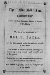
Blue Bell Inn advertisement
And now along the former Turnpike road.
We are going to start at the Blue Bell Inn or the Sussex Bell, Fernhurst Lane, just inside the Sussex border in the parish of Fernhurst. Here at the Blue Bell Inn a group of hardy Fernhurst people, who perambulated the Boundaries of the Parish over four days in November 1837, and after three cheers for their arduous undertaking being completed, were given a sovereign to spend at the Blue Bell.
The perambulation records crossing over or passing by the Turnpike road at various points within the Parish boundary.
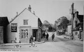
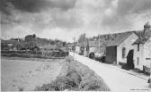
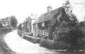
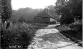
Old Road at former Shrimptons
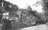
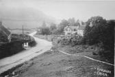
The Blue Bell Inn or the Sussex Bell, which I have just mentioned, was just further on from this row of cottages at Kingsley Green.
This 1930’s photo shows the narrow road of that time passing very close to the old row of cottages at Kingsley Green. This stretch of road was where wide vehicles such as buses couldn’t pass each other at the same time – they overlapped by a few inches. The main A286 road was straightened and widened in the 1960s, leaving this part of the old road as a lay-by and parking area for the cottages.
I’m sure some of you will remember how the road was before the 1960s.
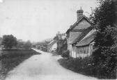
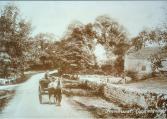
further along at Kingsley Green
Further along the road at Kingsley Green, heading towards Fernhurst, and the road scene in 1905. More like a country lane than main road. Note the narrow road and sharp bend. Kingsley Green used to be called Kingsley Marsh, and was drained as a project for the unemployed after the First World War.
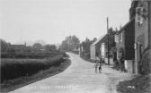
before the Toll House
Still Kingsley Green. As far back as 1938, “The Parish Clerk was instructed to write to the County Council further urging upon them the necessity of widening the stretch of road from Kingsley Green to the Sussex Bell and the provision of a footpath by the roadside”.
However, this was still a dangerous bend for cars to negotiate in the 1950s. The cottage and buildings on the left in the photo were demolished to widen the road.
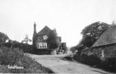
Toll House
The cottage called the “Tolle House” at Kingsley Green was not, in fact, the actual Toll House. The original little cottage was tucked into the bank opposite and a gate barred the highway. In 1861 a toll collector was still recorded as living there. By 1864 the road toll system was abandoned by Parliament.
An example of an old toll board can be seen in Haslemere Museum. There were various grades of tolls for coaches, wagons, carts, etc, and the number of horses or oxen pulling them. Tolls were also charged for number of cattle, sheep, swine, etc.
In order to avoid paying these tolls, carters and wagoners made a detour down Van Common and along Van Lane to the Cross. The procedure was reversed travelling back to Haslemere. No doubt this happened in full view of the toll collector!
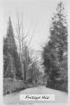
Friday’s Hill
Early in the 1900s it was recorded that Friday’s Hill was very steep for horses and oxen with heavy loads. The left-hand side of the road was kept very rough on purpose. Heavy wagons had no brakes, and flat bits of metal fixed with chains were put under the wheel.
The road was widened and straightened in the 1960s for to-day’s traffic, and part of the old road can be seen as a lay-by at the top.
Now, we mustn’t forget the Friday’s Hill Ghost. There may be a couple of others, but this one walks the hill. At least three sightings have been recorded of a maid in a cap and apron, and carrying a tray of glasses, walking the hill, and then vanishing.
Those of you going up the hill tonight should be safe, as all recorded sightings, so far, have been on summer evenings.
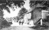
the Old Spread Eagle
The road scene taken in 1908, by the Old Spread Eagle, almost at the Cross roads. The old pub was demolished in 1935 because it stood too close to the main road. A new Spread Eagle was built shortly afterwards, further back from the main road, but that too was demolished in 1988, and now we have the houses of Tavern Court and opposite.
Fernhurst Cross Roads, early 1940s
It was more common to see people cycling in the 1920s and ’30s. Most men rode bicycles to get to work, or still walked, or a few went by bus. Boys started to cycle from about 12 years old, and girls started cycling when they left school at 14, when many went into service.
This is an early 1940’s photo. “Keep Left” bollards were introduced at the junctions of Vann Road and Church Road to cater for the increase in traffic.
Despite the hazard of the Post Office corner, traffic was two-way along Church Road and could exit on to the main road. (We still see the occasional car trying to come out of Church Road.)
As far back as July 1910 the Rev Douglas R Barton wrote a letter in the Parish magazine requesting “a simple scheme for lighting the main roads in the centre of the village”.
Street lighting; road danger to cyclists; bad road condition of Hogs Hill; danger signals requested at the Cross and Cooksbridge; road widening at the Cross; and even asking people not to turn their cows out on the Green during the May Day festivities, all seemed to feature as regular items in early Parish Council minutes.
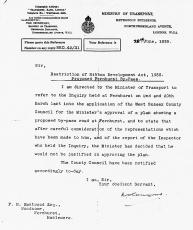
by-pass for Fernhurst
Interestingly, I found a letter in the Archive, from the Ministry of Transport dated 28 June 1939 to Mr F H Eastwood, living at Woodsome, Friday’s Hill, concerning a proposed by-pass road for Fernhurst. However, the Minister “decided he would not be justified in approving the plan”.
The fact that a by-pass for Fernhurst was considered in the 1930s is very interesting. Would it have been down Van Common? Or from Upper Cross and along the land that became West Close? Where would the by-pass have come out – near Cooksbridge? If anyone has any information, we would be very interested to know.
(Incidentally, Mr Eastwood, to whom the letter was addressed, was Francis Hurst Eastwood, a renowned Victorian artist. He moved to Fernhurst with his wife, Frances Annie, in 1926 when their daughter, Nina, married Dr Duke’s son. Mr Eastwood died in 1944 and is buried with his wife in Fernhurst cemetery.)
Before continuing along the Turnpike road, we’ll divert first to Vann Road (or Van Lane as it was originally called) and then across down Church Road to the Green.
early view of Van Lane
A late 1920’s view of what was Van Lane, which was renamed Chapel Street in 1903, then Vann Road as now. Before the cottages, chapels and Hawksfold House were built in the Victorian era, this was all common, stretching from Van Bridge to the Cross. This was the track taken to reach Van Common and out at Kingsley Green to avoid paying the tolls.
Vann Road, mid-1930s
I’ve added this mid-1930’s photo of Van Lane/Road to show how peaceful the road scene was, with fields on the left.
Vann Road, circa 1950
And another circa 1950. No change to the scene, apart from the addition of pavement. The fields are still there on the left.
Now a diversion down Church Road to Fernhurst Green.
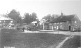
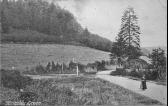
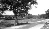
village green
An old scene of Fernhurst Green. The road looks more like a track in 1905, and gives a good example of how our roads were, dusty in summer and wet in winter.
It used to be all common from the Cross to the Green and down what was to become the Lickfold Road.
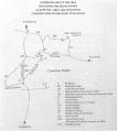
HARP map
This track via Ropes Lane and Lower House Farm might have remained as the highway to Lickfold were it not for a dispute over who was liable for the maintenance of it.
Interestingly, the Archive has a copy of a Henley Action for Rural Preservation report, which gives a little background.
In 1844 Captain James Henry purchased the Blackdown Estate from William Henry Yaldwyn, which included Lower House Farm. Within 7 years of the appearance of the 1846 Parish Tithe Map, a furious row broke out between Captain Henry and the Parish over who was liable for maintenance of the road passing over his property to Upperfold Lane. Captain Henry and his predecessors, no doubt, were quite happy to maintain their estate road as a permissive right by locals, until the cart traffic became too much. The dispute rumbled on, until the problem was resolved in 1856 by Captain Henry and two adjoining landowners, Mr Quantock and Mr Dennett, giving land for “new line of road of great public benefit”.
Thus the Parish agreed to the conversion of an existing bridleway into a cartway, leading from the Green through Sewards, Obern (Home) and Bridgeland Farms. Fernhurst and North Ambersham Parishes agreed to share the expenses of the new road from Upperfold Lane to the Green.
The stretch of road was always referred to as the “New Road”, but now it’s known as the Lickfold Road.
Lickfold Road Corner, Verdley Gates
We are now on the corner of the former ICI cricket ground, Lickfold Road corner. These were entrance gates to Verdley Place. Alice Tudor in her Fernhurst book, published in 1934, mentions them.
(The stone pillars are similar to the ones to the Old
Rectory, going up Friday’s Hill, and which used to be called “Marriott’s
Gates”.)
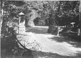
Verdley Gates, looking out towards the corner
Another view of the Verdley Gates looking out to the road corner. Perhaps someone can shed some light as to what happened to them and when?
If anyone has some more photos of the gates, please let us know.
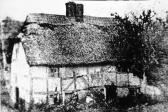
The Old Hole
This very old thatched cottage called “The Hole” or “The Old Hole” stood near to the corner opposite the Verdley Gates, and is included on an 1875 map. Alice Tudor in her Fernhurst book described it as lying “in a hollow between two hills” and “standing in a dilapidated condition and was pulled down”. Maybe some of the stones were still standing in the 1920s/30s? We wonder if anyone has any more photos or knows something of the history? Which families lived there?
Now returning to the main road, the Turnpike road.
view down Midhurst Road and Cottages
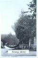
Cooksbridge
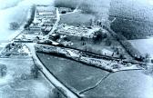
aerial, old and new Turnpikes
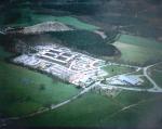
This was the former WW2 Army camp. The 13th Field Survey Squadron, Royal Engineers, were the last inhabitants before the MOD sold the site by auction on 25 November 1964. Bidding started at £15,000 and the property was eventually sold for £25,000 to Plant Protection Ltd (then a subsidiary of ICI), who, as we know, in 1945 had purchased the joining Verdley estate.
This aerial view shows the original “Old” Turnpike road, running in a straight line (from left to right in photo) from the King’s Arms up to Henley. Extra horses were kept at the King’s Arms to help pull coaches and laden wagons up Henley’s steep and narrow incline.
The new road with easier gradient was constructed in 1825, breaking away (to the right) at the King’s Arms, and making a wide sweep over Henley Common before joining the old road at the top of Henley hill.
Of course, the “new” road is now the current A286.
new access road to Henley and ICI
Isn’t it amazing how soon we become used to changes in the landscape.
new Turnpike, Henley Common
As previously mentioned, this section of the Turnpike Road, from the King’s Arms to the top of Henley Hill, was constructed in 1825 to eliminate the need for traffic to climb the steep and narrow road through Old Henley.
Still a steep climb, though, up Henley Hill.
In fact, local people in the 1920s/30s recall School outings by coach to Bognor, when everyone nervously wondered if the coach would ever get up Henley Hill or be able to stop when going down the other side to Budgenor. And then there were the same fears to face on their return journey.
Old Henley, 1930’s scene
A 1932 excavation concluded it was not possible to date the road with any certainty. The idea of possible Roman origin was finally disposed of by the finding, well below the pavement and close to the undisturbed clay, a fair amount of iron slag of blast furnace date. The road surface could not have been laid earlier than 1550, the earliest date for a blast furnace. It seemed likely that the paving was only laid down during the last half of the 18th century.
A later survey in 1949 by the Sussex Archaeological Society mentions “It seems most unlikely that such a paving would have been laid for coach horses, which would have found it rather dangerously slippery, and a use by draught traffic, such as the earlier iron-working produced, is more likely. This would accord, too, with the Tudor iron slag found under the stones. But it is almost certain that the original road is much older, of Roman or pre-Roman origin, from its direct alignment and relation with Chichester, and one cannot dismiss the possibility that the paving dates from that age and has been re-laid from time to time, especially under the heavy use of the Tudor iron-working.”
Roman or not, this is the last stretch of the Old Turnpike road in Fernhurst Parish. Both the Old Turnpike and the New Turnpike diversion of 1825, now meet at the top of Henley Hill, the current A286.
And so ends our tour of Highways Old and New.
Information gathered from: Fernhurst Archive; HARP; Brian Silver; “Fernhurst, The Story of a Sussex Village” by Alice M Tudor (1934); Fernhurst Oral History.
The Fernhurst Archives
